By Stephen Brend- Project Science Officer
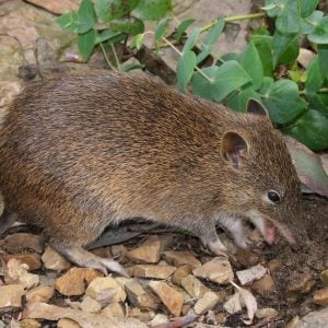 Our project “Can the Bandicoot Cross the Road?”, an assessment of the feasibility of using translocation as a conservation tool for Southern Brown Bandicoots, is entering its final stage. It is very exciting. The first phase of the project looked at the practicalities and feasibility of translocating bandicoots: what was required, what it would cost, what would be the likely outcome? The conclusion, as we have reported earlier, was that translocation was not only feasible, it was recommended. There seems no other way to reestablish a population of bandicoots. They cannot disperse on their own. There are two many threats and obstacles.
The next question we looked at was where the bandicoots come from? Here, we got a surprise. There is not one single eligible source population left in the State. All Southern Brown Bandicoot populations are showing very low levels of genetic diversity. If we moved animals from one location, we would not only bring that problem into the Biosphere Reserve, we might make it worse. Only a relatively small number of individuals would be translocated to act as the founders of the new population. Fewer individuals means fewer mate choices and that inevitably leads to a decline in genetic diversity. This is a problem as it could lead to poorer health, reduced fertility and increased susceptibility to disease. The only solution is to source bandicoots from either a genetically diverse population or individuals from multiple populations that are geographically separated, such as from East Gippsland and Mt Rothwell, in the west. Each breeding cycle would then bring about genetic mixing, hopefully, leading to a genetically healthy translocated population.
The third issue we looked at was suitable sites into which bandicoots could be released. The Department for Energy, Environment and Climate Action (DEECA) laid out some strict criteria. Foremost amongst these was that the site had to be greater than 200Ha with effective introduced predator control. There was an obvious candidate: Millowl (Phillip Island). Extensive discussions and site visits have resulted in agreement in principle for us to work with Phillip Island Nature Parks on this.
We are not ready to establish a SBB population on Millowl yet. There is more work to be done and we need to secure adequate funding. However, we are establishing the connections – that’s our strength – and laying out the pathway ahead. The final part of the project will be a translocation proposal written in accordance with DEECA’s template. We are very grateful to Gippsland transport for funding this work.
By Stephen Brend- Project Science Officer
 Many people are familiar with shelter belts – lines of trees that break up wind flows. This is perhaps the simplest and most common “nature based solution”, which is the use of natural products, ecosystems and structures to address environmental problems, particularly those caused by climate change. When most people hear the word “breakwater”, they probably picture a high concrete and stone wall. But why couldn’t the breakwater be an oyster reef? That would be a nature-based solution.
There are countless more examples: billabongs to absorb and disperse flood waters, mangrove plantings to diffuse storm surges, even using bees as pollinators is a nature-based solution. They are important for many reasons. Understanding and accepting natural water flows, for instance, rather than trying to block or control them, is both easier and more cost effective. Nature based solutions put more natural elements back into our environment, thereby increasing overall diversity and resilience. They regenerate naturally and are visually less intrusive. However, the real reason why they are important is because they are a solution. The climate crises is upon us. We need to adapt and mitigate. It is far better for us to start working with nature rather than against her.
By Annie Leitch, Communications and Events for the Fitzgerald Biosphere Community Collective (FBCC)
 During National Science week in August, the FBCC and UWA Walking together project team came together to showcase research alongside UNESCO Biosphere principles for the local community.
Merningar Bardok Elder and UWA Research Associate Auntie Lynnette Knapp welcomes and shares with us personal stories from her childhood, endorsing research and sharing her lived experiences as she teaches us; ‘..Country evokes the story’.
Nathan McQuoid, Chair of the FBCC, shows us where we sit geologically and socially ‘..to get our heads and hearts around the place’ and begin to ‘..get the dogma out this stuff and start knowing Country.’ Providing FBCC updates and valuable take homes for us all as community members within the Fitgerald Biosphere.
Professor Steve Hopper follows ‘you have anywhere between 10, 15, 20, 30 endemics depending on how you define it (East Mt Barren)..people get excited about the Fitzgerald (National Park), but it ain’t half the story. It’s your properties in the buffer and transition zones too’
Dr Alison Lullfitz and PhD Candidate Ursula Rodrigues compliment the narrative by highlighting the two-way science approach to research that underpins the Walking together project work. One catalyst to demonstrate this was looking for the gaps between the National Biodiversity Hotspots (places needing the most attention within the nation) and overlaying the use of Traditional Ecological Knowledge (TEK) when informing these conservation areas/projects and what it is required to achieve good regenerative, cultural and ecological outcomes.
As the Fitzgerald Biosphere region lays at a Noongar nation crossroads we acknowledge the Menang, Goreng, Merningar, Wirlomin and Wudjari Custodians and their Elders. By utilising two-way science methodology, engaging with Biosphere principles of reconciling sustainable development alongside conservation of biodiversity and looking at how we can understand these landscapes together, we as a community can celebrate OUR Fitzgerald Biosphere. Following on from the 11th WNICBR conference held at K’gari earlier this month – WE are ALL Connected.
By Glenn Brooks-MacMillan – Program Manager
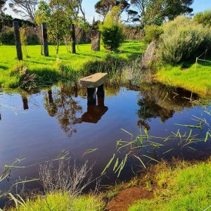
In recent years the Foundation has been busy implementing a range of Water Steward Plans across the Reserve. These plans essentially are actions for landowners to protect, enhance and regenerate our waterways. The stewardship approach builds the capacity of the landowner to better understand the risks associated with water management on and around their property.
 While saving water is one initiative, the basic principle is about improving the water quality and quantity to best suit the enterprise’s objectives. This process is achieved through close interaction with the landowner and sharing the risks and associated opportunities. The landowner eventually develops a plan and commits to the implementation over an agreed period.
What do I normally see as the outcomes?
A combination of returning the land to its original condition many hundreds of years ago, while integrating the production benefits the land has to offer. To do this an understanding of the history of the catchment and how the property fits within a whole system begins the vision which assists in the re-aligning, re-establishing, and re-generating waterways to way they used to be.
In many cases the outcomes are achievable, practical, and cost effective, but more importantly integrating natural systems into the production of the property.
In almost all cases our waterways have changed where vegetation has been removed, invasive plants and animals introduced, and pollutants and contaminants are present. Assessing the property from a water perspective has enabled several landowners to become more aware of the risks and develop plans to help improve the waterway.
 In early 2020, the Foundation began discussions with Willum Warrain Aboriginal Association, Mornington Peninsula Shire Council and DEWLP, to brainstorm the idea of improving the water way adjacent to the site that Willum Warrain operate from.
Thanks to the input from Uncle Peter Aldenhoven, CEO Willum Warrain Aboriginal Association, the concept quickly adopted the name ‘Healing Water Country’. Peter has been passionate about the approach and has demonstrated through practical solutions ways in which redesigning and rethinking how water originally moved throughout the catchment results in a more sustainable outcome.
We are delighted to announce that thanks to Peter’s passion and hard work, we have connected his wisdom and knowledge to an area in Boneo to build on the Healing Water Country approach by integrating First Nations principals into the design of improved water ways. This exciting project will build on existing works to improve a section of the Tootgarook Wetlands through the implementation of a ‘Healing Water Country – Revillaging Project’.
Thanks to the support of the Port Phillip Bay Fund, the aim of the project is to work with a range of First Nations people and the landowner and neighbours to implement an improved waterway.
This sort of catchment works, and design is an example of what the Foundation is working on with a range of landowners and managers across Western Port, as part of the Blue Carbon Planning Project that is developing management plans to help protect, enhance, and revegetate Saltmarsh, Mangroves, and seagrasses.
If you are interested in knowing more or wanting to participate, then please contact us and we can discuss further some of the options available.
By Julie Trezise- French Island Landcare Group
Feral Cat Free French Island Project/Two Great Ramsar Wetlands Project
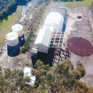
In November 2022, 70 Enduro Swift 4G enabled cameras, solar panels, SD cards, rechargeable batteries, sim cards with 12 month pre-paid plans, 12 month subscription to the Artificial Intelligence software program eVorta were purchased with funding from Melbourne Water and Western Port Biosphere. Additional hardware was purchased by French Island Landcare Group through Ramsar fundings which included hardwood stakes, metal brackets and bolts for installation of the cameras and solar panels in the field.
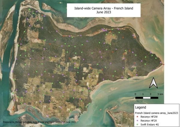 Julie Trezise and Michael Johnston configured the cameras, designed their placement and completed the installation and ongoing monitoring. Design of additional camera monitoring and installation aimed to increase coverage across the whole island landscape to further assist with population estimate modelling whilst also taking advantage of known pinch points to provide vital intel to operational crews.
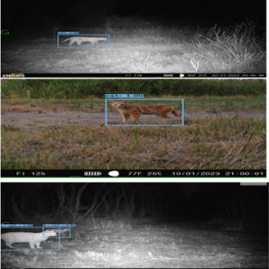
Installation began in December 2022 and was completed in mid-January 2023. Feral cat trapping operations ran from mid-January to the end of February. The eVorta subscriptions were set to alert the presence of feral cats in real time. All cat alerts were sent to Parks Victoria and the operational crew every morning to provide vital intel for targeted trapping. Feedback was very positive, receiving daily intel of feral cat locations during operations was incredibly helpful.
On-ground operations have stopped since the end of February, however the alerts continue to be forwarded to Parks Victoria and trapping crews daily. The number of cat detections has increased in June 2023 and now we are seeing multiple cats and kittens across the entire island and cat detection alerts are daily.
The first service of these new cameras and the original cameras was completed in June 2023 by Michael Johnston and Dave Caldwell with help from Bunurong Land Council and Parks Victoria. Three cameras were stolen and four were not working and sent back for repair under warranty. These cameras have since been reinstalled.
Wildlife are captured by the cameras and help tell the story of the benefits from reducing predation pressure through the removal of feral cats from French Island. There has been a noticeable increase in single images with multiple potoroos and many more images of ground nesting birds with chicks and other cool wildlife interactions. The suppression of feral cats has had a positive impact on wildlife.
Parks Victoria has a new Project Officer, Lucy. They have plans to undertake a cage trapping pulse in August to October and may include some night shooting.
 French Island Landcare Group continue to support Responsible Cat Ownership. We encourage all cat owners to have their cats on our database with up to date photos of both sides of the cat. De-sexing and micro-chipping remains fully funded, please contact us to help organize this. Research suggests that cats that are kept in enclosures and not allowed to roam actually live much longer lives and our wildlife also benefit from this arrangement. Collars and shaved sections of the tail help to identify the domestic cats on camera and if caught in a trap.
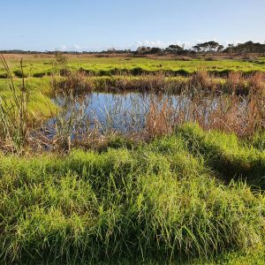
Western Port Ramsar Enhancement Project
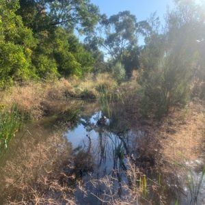
French Island Landcare Group has partnered with Melbourne Water to deliver priority actions that contribute to the protection of enhancement of the Western Port Ramsar site. French Island Landcare Group has engaged with landholders to control coastal woody weeds and manage rabbits within the surrounding coastal saltmarsh vegetation community.
The Western Port Ramsar Enhancement project aims to protect, maintain and enhance the ecological values of internationally significant wetlands in the Western Port Ramsar site. French Island Landcare Group received funding from Melbourne Water to contribute to this project by managing European rabbits and coastal woody weeds. Rabbits impact Ramsar wetlands through excessive grazing on delicate habitat such a saltmarsh. They dig extensive burrow systems which also damage these fragile ecosystems. Woody weeds provide excellent harbour for rabbits and out-compete our native vegetation. An integrated management approach of rabbit control using multiple tools combined with woody weed removal to reduce harbours is important to increase the success of the project.
 This is a multiyear project. In 2022/23, we completed the first pulse of rabbit control. Starting with a baiting program across 3 adjoining properties, followed by an intensive shooting program on 10 properties. Hutches were used throughout the baiting pulse to minimize impact on the baits from rain and reduce non-target uptake of baits. The baiting program reduced the rabbit population on these properties however, wet weather was a hindrance and therefore the next baiting program will be delivered over the summer months to improve the efficacy and longevity of the baits and improve the outcome. The shooting pulse ran over 6 nights and despite rain on 4 of those nights the team removed 270 rabbits, which will make a significant difference to the landscape in these areas. Timberscope were engaged to complete this work, they did a great job and were very professional.
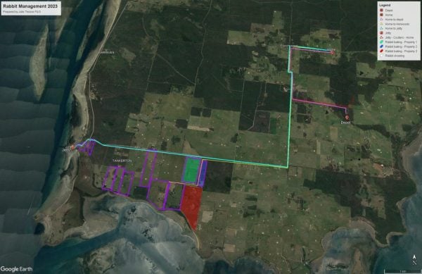 Woody weed works will be completed in 2023/24 financial year along with a second pulse of rabbit control involving both baiting and shooting. The output deliverable of 20 Ha of woody weed control was not met but we will deliver at least 30 Ha of woody weed control on coastal properties in the next financial year. We exceeded out environmental works output for pest animal control (rabbits) which was a target of 20 Ha in 2022/23 and delivered 108 Ha of baiting and 219 Ha of shooting.
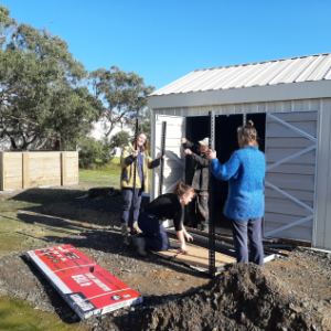
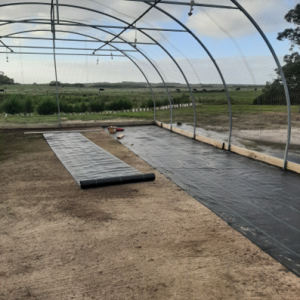
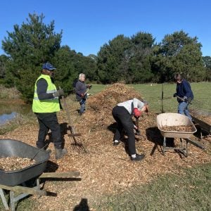
Nursery and Community Garden Update
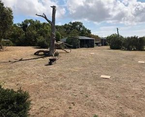
 We have completed stage 1 of the Nursery/Community Garden. We have moved in and have commenced the new growing season. Stage 2 is the garden design. That is a work in progress. Our next major job is the rabbit proof fencing and the gravel pathways.
As you can see in the photos, we have been very busy. The soil bay proved to be a challenge, as some of the screws were stuck hard in the timber and wouldn’t budge. It was a case of pulling it apart. Re-assembling it, was much easier. The weed-mat has been laid, the sprinkler system installed and the benches put in place, ready for the plants to be moved in. Shelving has been put together and placed in the shed and is now full of all our pots and equipment. The Chem Shed has also been moved and all gardening tools are hanging in their respect places. The pergola has been finished and a small power systems has been installed.
Lucy Kyriacou- Project Manager
It’s been a busy start to the new financial year with multiple projects being managed across the talented team. Projects ranging from small budgeted initiatives, such as supporting community groups like the Friends’ Of Haig Street, Bittern, turn a weed infested paddock with low biodiversity value, into a haven for wildlife, to multifaceted projects with multiple elements and stakeholders, such as the blue carbon planning project, which aims to plan for the future of coastal wetlands on a site-by-site basis across Western Port to support landholders to conserve and enhance these incredible ecosystems.
Read on to find out more.
Blue Carbon planning:
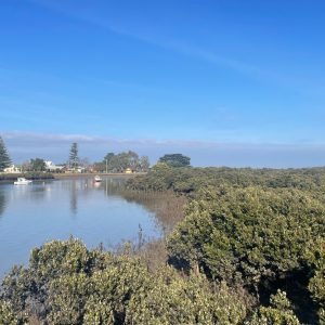
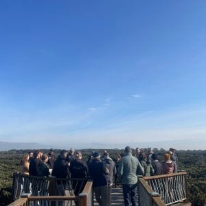 World Mangrove Day, on July 26th, saw the first stakeholder working group meeting take place in the Tooradin District Sports Club, nestled among the mangroves of the area. The day was a huge success, bringing together over thirty project stakeholders, including representatives from schools, DEECA, OzFish, Blue Carbon Lab, the Seagrass Partnership, Landcare, Councils, Moonlit Sanctuary, Nature Parks, and local landowners and landholders, to enjoy a schedule that included a mangrove walk and talk, and presentations from guest speakers, including Adrian Flynn from Fathom Pacific and Dick Cox from the Seagrass Partnership. The group participated in a workshop to gather foundational information for the blue carbon site assessments and management plans, and to start to consider areas of particular interest for the project and mark them on maps of Western Port. We were able to share with the group the work that the Blue Carbon Lab has commissioned for the seven neighbouring councils on ‘Blue Carbon Opportunities’ in the Mornington Peninsula & Western Port Biosphere Reserve. This work included a series of maps that shows the state of Blue Carbon before European settlement and the condition today. This information informed the participants and assisted them input their knowledge into areas for consideration for further planning. A summary of the report can be found here as part of a story map Blue Carbon in Western Port and Eastern Port Phillip Bay (arcgis.com).
The assessors have been busy over the quarter visiting properties and blue carbon ecosystem areas to connect with owners and experts around Western Port and build support for the project. Property owners have been interested to hear about the potential gains to be made for wildlife and to protect their productive land by conserving and enhancing blue carbon. Some landowners are already getting straight into it with installing exclusion fencing to help protect saltmarsh. One landowner did not realise that by removing a levee at the bottom of the property and letting tidal inundation happen they could create blue carbon habitat and improve the land’s ability to cope with sea level rise and increased intensity of storm surges. They said they would be very happy to look out across wetlands in the bottom paddocks. The aim of the project is to do a detailed business case on improving these ecosystems for each property, helping the landowner to make a more informed decision on what they would like to do. There is growing evidence demonstrating that enhancing nature on farms increases productivity. More lambs survive because they are protected from the elements, and milk yields increase for dairy cows while beef cows gain weight, expending less energy by not having to keep hot or cold as they are protected with vegetation from wind and the sun. Access to cleaner and cooler water is also shown to improve productivity.
 In September we held a day to work with some of the leading technical experts in marine science and blue carbon in Western Port to start the design process for the blue carbon site assessment templates. Coastal wetlands are complex ecosystems with multiple elements to consider, and still much unknown about them, so any intervention to restore or protect them must be done with caution.
The Blue Carbon planning project is being supported by experts including Fathom Pacific, marine consultants with a long history of research and conservation in Western Port, Bass Coast Landcare, who have much experience in catchment management and mangrove restoration, Lance Lloyd, Aquatic Ecologist and Water Stewardship Advisor, with a career in hydrological systems management, and other experts such as Dr Pat MacWhirter, and saltmarsh and indigenous plant botanist, Gidja Walker.
In addition, we had planned for the day a cultural awareness event at the Bunurong Land Council Aboriginal Corporation venue in Frankston, to help raise our awareness on the cultural history and specifically the links in with healing water, sea and land country with opportunities to include First Nations perspectives in the design of the restoration activities.
We would like to thank everyone for their interest and engagement in the project and look forward to working together to achieve Western Port-wide blue carbon protection.
Please go here for more details about the project.
Blue Carbon planning in the Western Port Biosphere Reserve 2023/24 – Western Port Biosphere
Water Stewardship – public fund:
![]() $30,000 of the Public Fund, created through the kind donations by members and other donors, has been allocated this financial year to continue our work to create a network of Water Stewards across Western Port to improve catchment management practices, enhance water quality and conservation, and increase the value of properties for biodiversity.
$30,000 of the Public Fund, created through the kind donations by members and other donors, has been allocated this financial year to continue our work to create a network of Water Stewards across Western Port to improve catchment management practices, enhance water quality and conservation, and increase the value of properties for biodiversity.
This quarter has been the initiation of this process, with Water Stewards contacted and offered renewed support for their water stewardship ambitions. The team has been revisiting landholders, reviewing plans, updating action plans, and setting new goals for the future.
Many gains can be made from planting up and mulching riparian zones with indigenous species. This prevents erosion, slows the movement of water through catchments, and helps reduce the impact of flashy flows in times of high rainfall. It also has the added value of increasing habitat and improving the whole property’s value for biodiversity. Water Stewards such as Somers Camp, St Mary’s Primary, and Luxton Park have put in orders for large numbers of plants to achieve these goals on their properties.
This phase of the project also aims to support water stewards access funding through grants and to improve stakeholder knowledge of the cultural heritage values of waterways by engaging Traditional Owners to offer advice and, where applicable, carry out cultural assessments.
Queen’s Jubilee – Haig Street Reserve:
 Haig Street Reserve is a paddock located within a small estate of bush blocks in Bittern. Formerly, a large grassy expanse, with a few remnant eucalypts, a dam surrounded by blackberries and a creek lined with gorse. Other invasive species include watsonia and kikuyu grass. All this is in the process of evolution from a wildlife desert to a wildlife haven thanks to the hard work and dedication of a group of motivated residents who approached the Council to help them transform the site.
The remnant eucalypts have been linked together with ‘corridors’ of indigenous species and mulched to suppress weeds. The dam has been cleared of blackberries, mulched, and planting has begun to provide protection for ducks, small birds, long-necked turtles, skinks, lizards, and frogs. The side of the paddock with the creek has been planted up with canopy species for koalas, parrots, owls, tawny frogmouths, possums, and other native animals. The group meet once a month to weed, mulch, plant, and connect over a shared passion for supporting local wildlife and improving ecosystems for biodiversity.
The project has been enhanced through the Queen’s Jubilee grant from the Biosphere Foundation, which has provided extra plants, signage, a bench, and extra slashing and weeding days by contractors, Naturelinks, helping to rid the dam of hundreds of square metres of blackberries.
Biodiversity in Schools:
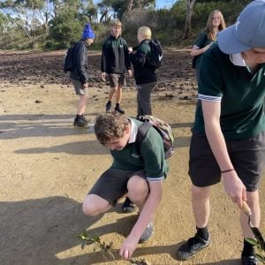 Our Biodiversity in Schools program continues with climate action and environmental restoration workshops for schools through the Climate Action, Blue Carbon Planning, Water Stewardship and the 2023/24 15 Trees projects. We always have opportunities available to schools through our fee-for-service program. Please see Biodiversity in Schools – Western Port Biosphere for details.
By Jacqui Salter- Community Environmental Education Coordinator, Mornington Peninsula Shire Council
 Bring your excess produce to our home harvest exchange and swap with other home gardeners. No coins needed – fresh produce is all the currency you’ll need. Meet likeminded people and pick up some handy tips along the way.
We are launching the exchange on Saturday 4 November, 11am – 12pm
Stay a little longer and enjoy a free vegan lunch!
Register here: https://HarvestexchangeNov23.eventbrite.com.au
The harvest exchange will then run fortnightly on the first Saturday of each month 11am – 12pm and the third Thursday of each month 9.30 – 10.30am
Where: Eco Living Display Centre, The Briars 450 Nepean Highway, Mount Martha
More information: Eco Living Display Centre – Mornington Peninsula Shire (mornpen.vic.gov.au)
Contact: [email protected]

The Western Port Biosphere has undergone a significant change by unveiling a fresh logo. This logo marks a new era for this UNESCO Biosphere Reserve and signifies the Biosphere’s commitment to unity between humans and nature, as well as its readiness for the digital age. One of only five UNESCO-listed Biospheres in Australia, Western Port Biosphere needed a distinctive brand identity to increase community awareness and attract new partners and funding.
The new logo combines images of the region’s plants, animals, and the built environment, conveying a strong message that humans are an essential part of nature, not separate from it. The new visual identity represents the Biosphere and its inhabitants, humans, flora and fauna, living and working together in one connected ecosystem.
From the logo, which contains references to native species and local sculptures, to layered macro and micro photography to express the breadth and depth of the Reserve’s conservation and research work, the new identity allows the Biosphere to communicate on both a scientific leadership level, and an inviting community level.
The logo’s contemporary design, with clean lines and bold colours, makes it easily recognisable and memorable. This modern look aligns with current branding trends and suits the Biosphere’s goal of expanding its reach through digital channels.
We extend our gratitude to Western Port Biosphere resident, Joe Rogers of The Contenders for donating his time and talent to helping us identify and articulate the essence of our vision and purpose and the creative team Cúpla - Lyndal Kearney, Kayla Streatfeild and Justine Donaldson – who created a contemporary visualisation of these.
Renewed, refocused, and refreshed, the Western Port Biosphere’s new logo marks the beginning of our third decade in the global UNESCO network. It’s a symbol that speaks to our interconnectedness with nature and our commitment to its preservation.
Read our Press Release here: Biosphere Refresh Press Release
Read the full story behind the rebrand by the clever folks at Cupla here:
Western Port Biosphere — Cúpla | Strategic branding & design agency | Melbourne (cuplastudio.co)
Western Port Biosphere Reserve renewed and energised for another decade!
Our 10-year review submitted in 2022 to UNESCO was successful, recertifying the Western Port Biosphere Reserve as a member of its international biosphere network of 748 reserves in 134 countries. It retains our status for a third decade, allowing us and our partners to move confidently towards creating a sustainable future for everyone who lives, works and plays in the Reserve.
Of special significance was UNESCO’s acceptance of a revised zonation map for the 2,142 sq km Reserve, which better reflects how our communities’ interface with our core protected areas. We thank AECOM for its considerable contribution of expertise and technology to create this fresh perspective. This will enable better conversations on how our actions impact important terrestrial and marine ecosystems.
Read the press release here
"*" indicates required fields
PO Box 261, Hastings VIC 3915
Australia
Ph: (03) 5979 2167

Photography credits: J Harrison (eastern curlew).
Unless otherwise stated all content, including the logo, are copyright © Mornington Peninsula and Western Port Biosphere Reserve Foundation Ltd.
The content and logo must not be used without the Foundation’s written consent.


